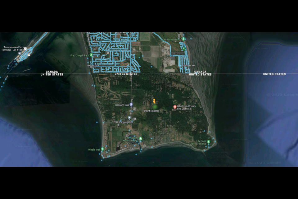
Google Street Views has mapped much of the world.
Zeballos, a hamlet of around 100 folks living on the northwest coast of Vancouver Island. Deadhorse Airport on Alaska's northern coast. The southern tip of 66a Street in Delta.
All have been visited by a crew working for Google's huge Street Views project, which has meticulously captured many of the world's roadways with geolocated photos, especially North America.
And while there are some holes in the map, like North Korea, most of B.C.'s Stikine Region, and Ascension Island (due to either being physically or politically remote), almost every square inch of roadway in the continental U.S. has been recorded, at least once.
The unusual situation of Point Roberts
Which is what makes Point Roberts, Washington so unusual.
In the 15 years Street Views has been active, it's never made it to our closest American neighbours. Or neighbors, as they would spell it.
The little peninsula is home to over 1,100 permanent residents (more in tourist season) with neighbourhoods, businesses, and parkland across its 12.65 square kilometres. It's separated from the rest of the USA by Boundary Bay, so if residents want to drive to their kids' high school and back, for example, they have to cross an international border four times.
It's relatively flat, easily accessible, and is one of the top 10 Canada-U.S. border crossings by traffic volume.
Google Street View teams get close to the peninsula; at least three times since the program started in 2007 a car has driven around south Delta. The border station between Point Roberts and Tsawwassen has been captured on Street Views in 2011, 2021, and 2022.
For comparison, parts of Vancouver, which sits about 23 km away, have been photographed up to 17 times.
"It's a disappointment, but it's not a surprise."
Brian Calder, a former Vancouver city councillor and current president of the Point Roberts Chamber of Commerce, isn't surprised his town has been overlooked for more than a decade.
"Having Google ignore us as well is not a surprise," he says. "It's a disappointment, but it's not a surprise."
For its part, Google says it's not ignoring Point Roberts.
"We tend to prioritize areas that change frequently and have a high volume of visitors. In a city, we often start downtown at the city centre, and then move outwards," a spokesperson told V.I.A. by email last year.
Many smaller, less populous, and less visited places have been visited by Street Views. When asked specifically by V.I.A. about why Point Roberts has been missed, Google didn't respond
Calder thinks he knows the reason.
"Point Roberts is an orphaned problem child," he says.
Point Roberts is an American exclave; those are parts of the United States that are physically in the country, but only accessible by road via Canada.
"It's typical of Point Roberts, we're an exclave, we're divorced from direct connection to our motherland," he tells V.I.A.
He notes that Point Roberts connection with Canada is strong, literally and metaphorically, with 50 per cent of residents holding dual citizenship.
At the same time, things like electricity and sewage service come from Canada. Calder notes one thing that hasn't crossed the border is housing prices, with similar properties within sight of each other selling for a quarter of their Canadian counterpart.
"They're literally 200 feet apart," he says.
Other exclaves in similar situations
There are two other American towns in similar situations. One is Hyder, Alaska, which is only accessible through Stewart, B.C.
The Northwest Angle in Minnesota is more similar, as it's technically part of the classic 'continental USA.' However, there's no town neighbouring it on the Canadian side.
Neither have been visited by Street Views either.
But both are far less populous (with around 100 residents), and both of the areas around them haven't been visited by Google more than once.
There's also the Canadian exclave of Campobello Island, home to just under 1,000 people. There's a bridge to it from Lubec, Maine; the town was visited once, in 2007. Neither the bridge, nor the border, was crossed.
The impact of not being seen
Calder says it's normal to be ignored, but as the pandemic recedes, that lack of being seen is frustrating.
The population in Point Roberts has been dwindling for years; he says the lack of government service and the pandemic have played a role in recent declines in both permanent and summer residents (some summers the community ballooned to 4,500 people).
"Generations of Canadians have been coming here for their summer vacations," Calder adds, noting that the pattern was broken by COVID-19 and border restrictions.
"We're suffering long COVID, but in a whole other concept," he says. "The economy was beaten to death by the lockdown."
With that said, he thinks getting the little town added to Googles Street Views could help reinvigorate interest in the community as a tourist destination.
"This is an open invitation to Google, we'll even drive them around," he says. "Put us on the map."


